Recently LiDAR has become one of the most rapidly expanding areas of remote sensing, and understanding this field is a vital part in becoming a well-rounded analyst. The goal in this lab was to further basic LiDAR knowledge and practice LiDAR data processing and structure. Specific skills practiced include: processing and retrieving various surface and terrain models, processing and creating an intensity image and other products from point cloud in LAS file format.
Methods:
Part 1: Point cloud visualization in Erdas Imagine
This part consisted of loading all necessary .las as point cloud in order to access the lidar point cloud tiles. These were visualized using Erdas Imagine before being brought into ArcMap.
Part 2: Generate a LAS dataset and explore LiDAR point clouds with ArcGIS
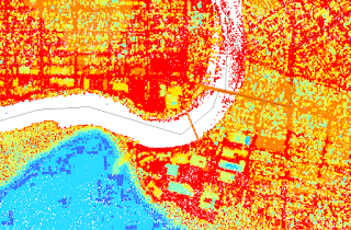
This part consisted of creating an LAS dataset, exploring the properties of LAS datasets, and visualizing it as point cloud in 2D and 3D. Figure 1 shows the LAS dataset in points by elevation. Figure 2 shows the walk bridge in the UWEC campus in 2D. Figure 3 shows the lower UWEC campus in 3D.
Part 3: Generation of LiDAR derivative products
In this part the following derivative products were created:
- Digital Surface Model (DSM) with first return
- Digital Terrain Model (DTM)
- Hillshade of your DSM
- Hillshade of your DTM
Results:
 |
| Figure 1 |
 |
| Figure 2 |
 |
| Figure 3 |
 |
| Figure 4 |
 |
| Figure 5 |
 |
| Figure 6 |
 |
| Figure 7 |
Sources:
LiDAR point cloud and tile index are from Eau Claire County, 2013.
Eau Claire County Shapefile is from Mastering ArcGIS 6th Edition data by Margaret Price, 2014.
No comments:
Post a Comment